File:FR map TA Cité Engloutie 2022-04-03.png
De Ryzom Commons
Pas de plus haute résolution disponible.
FR_map_TA_Cité_Engloutie_2022-04-03.png (541 × 485 pixels, taille du fichier : 323 Kio, type MIME : image/png)
Summary
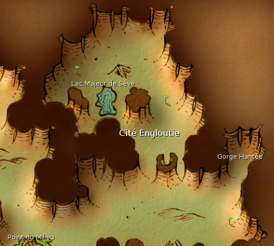
Map FR fr:Cité engloutie (Nord est des fr:Terres Abandonnées)
en:Sunken City (en:Wastelands)
Licensing

- 🇩🇪 — Dieses Werk ist lizenziert unter einer Creative Commons Namensnennung - Weitergabe unter gleichen Bedingungen 4.0 International Lizenz.
- 🇬🇧 — This work is licensed under a " Creative Commons Attribution-ShareAlike 4.0 International License.
- 🇪🇸 — Esta obra está bajo una Licencia Creative Commons Atribución-CompartirIgual 4.0 Internacional.
- 🇫🇷 — Cette œuvre est mise à disposition selon les termes de la Licence Creative Commons Attribution - Partage dans les Mêmes Conditions 4.0 Internationale.
- 🇷🇺 — Это произведение доступно по лицензии Creative Commons «Attribution-ShareAlike» («Атрибуция-СохранениеУсловий») 4.0 Всемирная.
You are free:
- to share: to copy, distribute and transmit the work,
- to remix: to adapt the work;
Under the following conditions:
- attribution: You must attribute the work in the manner specified by the author or licensor (but not in any way that suggests that they endorse you or your use of the work).
- share alike: If you alter, transform, or build upon this work, you may distribute the resulting work only under the same, similar, or a compatible license.
Historique du fichier
Cliquer sur une date et heure pour voir le fichier tel qu'il était à ce moment-là.
| Date et heure | Vignette | Dimensions | Utilisateur | Commentaire | |
|---|---|---|---|---|---|
| actuel | 3 avril 2022 à 15:22 | | 541 × 485 (323 Kio) | Craftjenn (discussion | contributions) | Map FR fr:Cité engloutie (Nord est des fr:Terres Abandonnées) en:Sunken City (en:Wastelands) Category:FR Map images |
- Vous ne pouvez pas remplacer ce fichier.
Utilisation du fichier
Aucune page n’utilise ce fichier.

